|
|
|
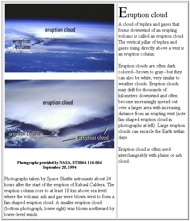
Chemtrail Clouds and Volcanic Ash Clouds Compared
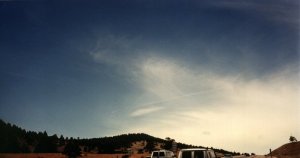
Denver, Colorado - 1999 |
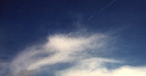
Julesburg, Colorado - 1999 |
|---|---|
Rabaul Cauldra - New Guinea - 1994 |
Mount Spurr - Alaska - 1992 |
Background
Living under today's unnaturally cloudy or whitened skies caused by chemtrails, the product of Aircraft Aerosol Operations (AAOs), one might wonder what the sky looked like after a large volcanic eruption, such as Tambora or Pinatubo. Eruptions such as these can cause great changes to earth's atmosphere by injecting huge quantities of volcanic ash into the stratosphere. Volcanically induced atmospheric changes are well known and documented.
The intent of this report is to illustrate possible
parallels that exist in the physical properties of two types of clouds:
1. Artificial clouds that are created by AAOs,
known as chemclouds and;
2. Volcanic ash clouds, also known as eruption
clouds or plume clouds.
It is important to remember that drawing such
comparisons is not necessarily an endorsement of the global warming chemtrail
theory. Instead, different species of non-meteorological clouds are compared
to see if they bear similar properties. If the two cloud types are similar,
new doors may be opened helping to solve the chemtrail mystery.
Do chemtrails and their clouds truly behave like
high altitude aircraft-cirrus clouds composed of ice crystals, or do they
mimic ash clouds composed of minerals which slowly descend to lower altitudes
as they gradually fall out of the atmosphere? Can we learn anything new
about chemclouds from the historical record regarding volcanic ash clouds?
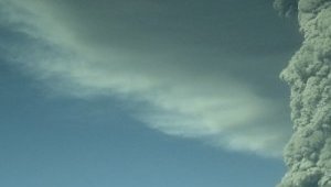
Ash Cloud Visual Appearance
Volcanic ash emissions may be seen in shades of white, appearing much like water vapor. Many would agree, parts of the accompanying images of ash emissions look deceptively similar to water vapor.
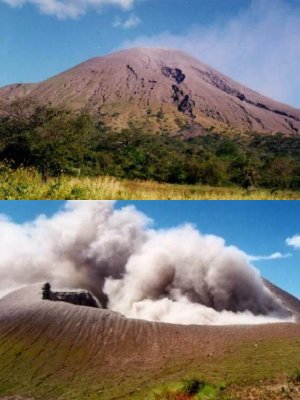
Volcanic Ash Emissions
Left: Telica, Nicaragua - 2000
Right: Guagua Pichincha, Ecuador - 1999
Note, in the second image below, as well as its enlargement (third down), the color and texture similarity of the eruption cloud to an expanded chemtrail. Pay particular attention to this clouds thinness and to the perimeter of the cloud, growing ever thinner, blending gradually into its surroundings. Also note the clouds tendency to be nonuniform, with random, zones of density, transparency or opacity. A trademark of ash clouds, as well as cirrus clouds, is a wispy appearance of cloud edges, giving them an irregular fringed appearance. These shapes seem to make sense, possibly due to a lack of cohesion of the particulate material.
Regarding ash clouds and wind direction, see above image and enlargement
(below): "The upstream edge can be thick; while
downstream, the ash cloud will becomes diffuse and thin. It will appears
the same as thick CI [cirrus]
on
the VIS, FIR, and enhanced IR imagery."
Identifying
METSAT features

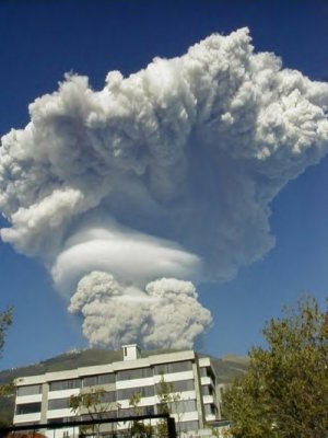
Enlarged Area, Eruption Cloud Image, Rabaul Cauldra -1994
Note the wispy, fringed appearance.
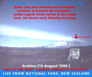
Ash Cloud & Whitened Sky, Mount Ruapehw,
New Zealand - 1996
Notice the whitened sky, does it resemble current
conditions?
Unnoticed Atmospheric Changes
Why do so many individuals, even scientists and professional pilots, fail to recognize the recent and dramatic changes to our atmosphere? Can pilots or other professionals visually discern differences between meteorological clouds and volcanic ash clouds?
"Downwind from an erupting volcano, pilots
have a very difficult time distinguishing eruption clouds from weather-related
clouds."
Danger
to Aircraft from Volcanic Eruption Clouds
"As the ash and gas move and disperse downwind,
it becomes increasingly difficult for aircraft pilots and scientists to
distinguish an eruption cloud visually from weather clouds"
Detecting
Eruption Clouds with Weather Satellites
"Unfortunately, it is possible to get into
a volcanic cloud without knowing it. This is especially true at night.
Volcanic clouds are not detected by aircraft radar systems, because the
particles in them are too small to have strong radar returns."
Volcanic
Ash Preparedness and Mitigation
Shadows Cast in the Atmosphere
There has been much discussion, among chemtrail observers, describing strange appearances of well defined dark or black shadows, cast onto clouds or atmospheric haze, in chemtrail laden skies. Dark shadows have been seen to (apparently) project onto a clear blue sky. More probable, the shadow is being cast onto, nearly invisible, fine particulate material. In the image below, the shadow of a fresh trail is cast across a span of sky which includes a relatively thick cloud, as well as highly diffused cloud areas. The shadow is extremely well defined across widely varying zones of cloud diffusion. Do meteorological clouds behave like this? How do ash clouds compare to meteorological clouds, in their ability to display shadows?
Chemtrail Shadow On Haze & Cloud Regions - Denver, CO - 2001
"Also at night, landing lights cast sharp,
distinct shadows in volcanic clouds, versus the fuzzy shadows made in meteoric
clouds."
Volcanic
Ash Preparedness and Mitigation
Unusual Atmospheric Electrical Activity
During the past two to three years, concurrent to chemtrail sightings, considerable attention has been paid to increased atmospheric electrical activity and unusual lightning. In 2000, frequent electrical storms with numerous and intense lightning strikes, combined with dry weather, caused many wildfires burning throughout the US. Also odd, electrical snowstorms are being noticed, surprising many who have no memory of such events. Are volcanic ash clouds also associated with electrical activity?
(Warning for aircraft)
"At
night, there is a heavy static discharge (St. Elmo's fire) around the windshield,
accompanied by a bright white glow in the engine inlets."
Volcanic
Ash Preparedness and Mitigation
Poor Visibility
Reports of poor or degraded visibility have been continuous since chemtrail operations began. Attempts by 'experts' to explain poor visibility include: Numerous forest fires, in the summer of 2000, burning throughout the US; An Asian dust cloud, in the spring of 2001, pushed to North America by winds; China's industrial pollution, in the spring of 2001, also driven to North America by winds. These explanations are not convincing. The visibility problem has persisted before and after the explained events, going unreported when no reason for poor visibility was available. The events themselves did not significantly alter overall visibility, which was poor regardless. Additionally, The National Oceanic and Atmospheric Administration (NOAA), recently altered their visibility reporting methods. NOAA's visibility graphs NCDC Climate Visualization (Global Summary of the Day), as originally reported and archived for numerous cities around the US, included visibility distances up to approximately 40 miles. The new method reports visibility distances up to approximately 10 miles.
"Natural visibility in the East is estimated to be between 60 and 80 miles, while in the West it is between 110-115 miles."
"Other trend analyses using California airport
data centered on adverse and superior visibility. Adverse visibility
refers to those days that have concentrations of visibility-reducing particles
sufficient to reduce prevailing visibility to less than 10 miles when the
relative humidity is less than 70%. Visibilities that are 30 miles or more
are termed superior.
Introduction
to Visibility (PDF)
(Linked From:
Visibility
Monitoring)
If the natural visibility range is from 60 to 115 miles, and, in a metropolitan area, 30 mile visibility is considered "superior" while visibility less than 10 miles is considered "adverse", why does NOAA currently exclude values greater than about 10 miles? Also see: Visibility Standards Changed.
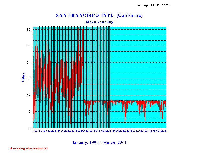
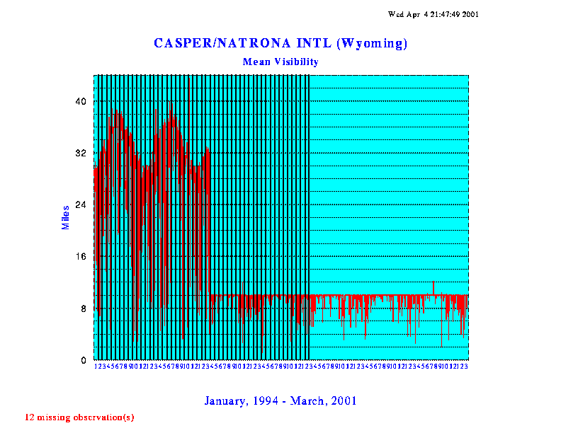
NOAA 'Chopped' Graphs
Left: San Francisco, CA, 1994-2001
Right: Casper, WY, 1994-2001
CLICK IMAGE TO ENLARGE
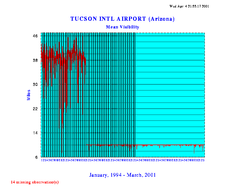
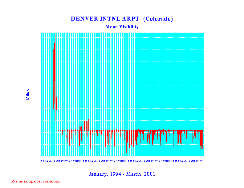
Left: Tucson, AZ, 1994-2001
Right: Denver, CO, 1994-2001
Does volcanic ash also degrade visibility?
"Ashfall (or tephra) consists of solid materials
ejected from a volcano that fall to the ground relatively close to the
eruption site. Ashfall can greatly reduce visibility near the ground, thus
inhibiting transportation."
Volcanic
Hazards Management
The image below reveals poor visibility after the 1992 eruption of Mount
Spurr, Alaska.
"Ash on the ground in Anchorage became resuspended
in the air with the slightest breeze; vehicular traffic also contributed
to unhealthy particulate levels in the air over the city. Many residents
resorted to particle masks and had to take precautions to protect sensitive
electronic equipment, car engines, etc. People with respiratory sensitivities
were warned to stay indoors and keep physical activity to a minimum. (photo
by R Emanuel, 8/19/92)"
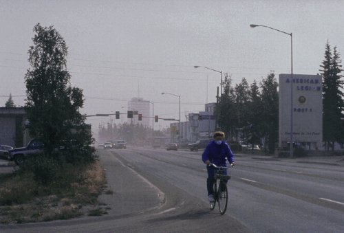
Ashfall Visibility - Mount Spurr, Alaska - 1992
Eruptions
of Mount Spurr Volcano, 1992
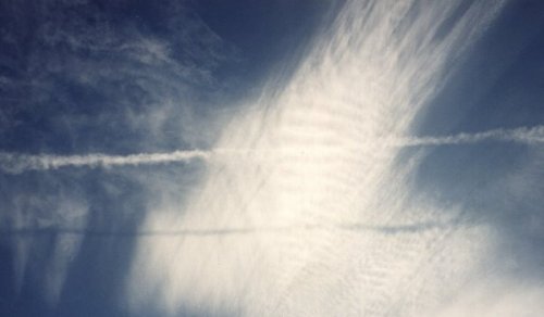
Poor visibility, as seen in the following two images, has become commonplace. When associated with a volcano or a forest fire, poor visibility is big news. The same or worse visibility, as seen below, associated with AAOs, is not newsworthy. This is not fog - Images were taken on warm, sunny afternoons with low humidity.
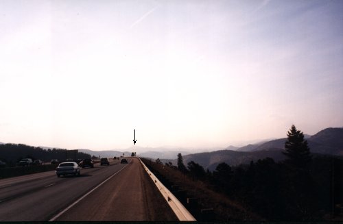
AAO Visibility - West of Denver, CO
- 1999
Approximately 8 miles to the mountain peak under the arrow.
Notice the chemtrail streaks, upper part of image. Looking opposite
(east), the sky looked blue.
Bright illumination, looking generally toward the sun, enhances aerosol
visibility.
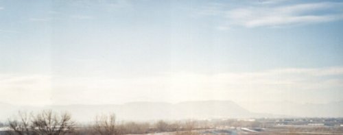
AAO Visibility - Golden, CO - 2001
Three miles to flattop mountains. Similar effects, described in above
image.
Below, in the image of Rabaul, notice the poor visibility and variable visibility caused by varying distribution of volcanic aerosols. Notice how the low altitude volcanic aerosols partly obscure the cumulus clouds. These effects are not unlike everyday scenes in today's hazy skies, as shown above and reported by citizens across the US and beyond.
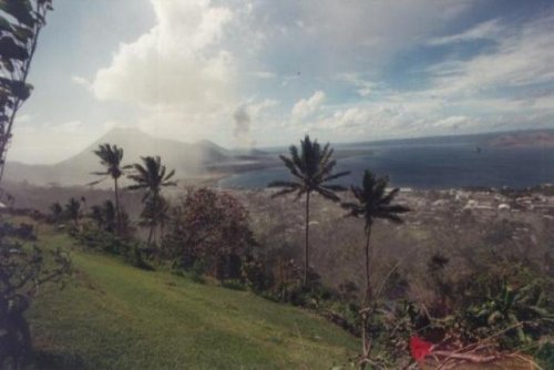
Ashfall Visibility - Rabaul, Papua New Guinea - 1998
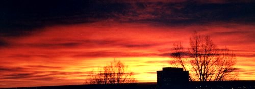
Unnaturally Colorful Sunrises and Sunsets
Unnaturally colorful sunrises and sunsets, rising high above the horizon, occasionally encircling the entire horizon, concurrent to AAOs, have also been widely discussed and photographed. At first glance, some have actually been mistaken for an explosion, invoking fear or great surprise within the mind's eye. What sort of sunrise/sunset coloration would be expected following a major volcanic eruption?
"The June 1991 eruption of Mount Pinatubo was
global. Slightly cooler than usual temperatures recorded worldwide and
the brilliant sunsets and sunrises have been attributed to this eruption
that sent fine ash and gases high into the stratosphere, forming a large
volcanic cloud that drifted around the world."
Volcanoes
and the Weather
"Brilliantly colored sunsets and prolonged
twilights were noted all over the world after the August 1883 eruption
of Krakatau, Indonesia, as the result of the global spread of aerosols
from the eruption throughout the stratosphere. These displays were recognised
as distinct from the familiar red sunsets."
Volcano
World

This photo shows a view of Mt. Pinatubo looking northeast at sunrise.
Copyrighted photo by Marko Riikonen.
Sunrise Coloration, AAO Aerosols, Denver, CO - 1999
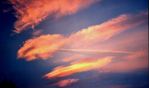
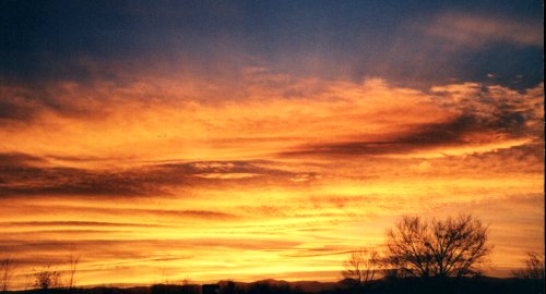
Sunset Coloration, AAO Aerosols, Denver, CO - 1999
Clouds high above the horizon extremely bright, glow with unnatural
brilliance.
Fresh chemtrail near center. This particular sunset exhibited brilliant
orange to pink
coloration throughout the entire sky, even at the eastern horizon.
Sunset Coloration, AAO Aerosols, Same Sunset Above
Streaks of highly diffused aerosol film seen in front of blue sky at
top of image.
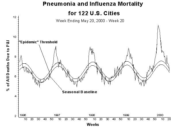
Health Issues
Respiratory illness has also been on the increase,
concurrent with AAOs. According to the Centers for Disease Control (CDC
graphs below), percentage of all deaths due to pneumonia and influenza
reached a peak of 11.2% in January of 2000, 172% of the epidemic threshold.
Influenza
Summary Update (2000)
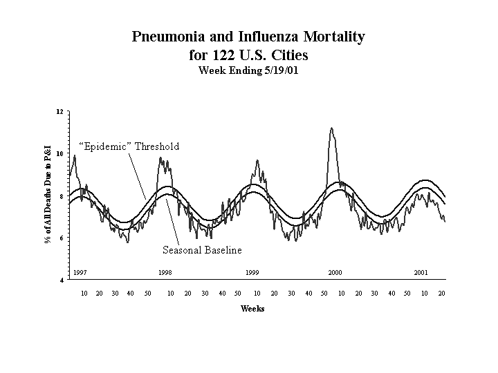
In 2001, the CDC's definition for epidemic threshold
was elevated from 6.5% to 7.6%. Additionally, the CDC's graph of the 2000-2001
flu season is missing the characteristic spike, seen in prior year flu
seasons. Has the CDC's reporting methods also changed, like NOAA's visibility
reporting standards?
Influenza
Summary Update (2001)
What does the historical record reveal about volcanic ash clouds and health?
"Ashfall (or tephra) consists of solid materials
ejected from a volcano that fall to the ground relatively close to the
eruption site...The ash can also cause respiratory illness and damage electronic
equipment and machinery."
Volcanic
Hazards Management
Possible Delivery Mechanism for Aircraft Aerosols
Consider the possibility of injecting mineral materials directly into a jet engine's exhaust stream.
"Volcanic ash consists of silicates, which
melt in the combustion chamber of modern jet engines (which operate at
1400 degrees F),[correction: 1400 degrees
C]then solidify on turbine blades, reducing
engine performance, and possibly resulting in a stall. . .While there have
been no known fatalities due to aircraft entering volcanic ash clouds,
there have been at least two near disasters in Indonesia and Alaska."
Volcanic
Hazards Management
"The temperature of the gas after combustion
is about 1800 to 2000 °C, which is far too hot for entry to the nozzle
guide vanes of the turbine. The air not used for combustion, which amounts
to about 60 percent of the total airflow, is therefore introduced progressively
into the flame tube. Approximately one third of this gas is used to lower
the temperature inside the combustor; the remainder is used for cooling
the walls of the flame tube."
Principles
of jet engine operation
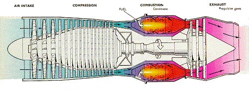
Cutaway View, Jet Engine
Also see:
Possible
Engine Modification For Sprayplane
Weather Satellites and Detection Capabilities for Aerosol Clouds
Both ash clouds and chemtrails are seen within the visible spectrum in satellite imagery. Other types of weather satellite imagery apparently do not reveal chemtrails. Do ash clouds have similar imagery related properties? What special imagery techniques are required to reveal ash clouds or other types of aerosols?
"Weather satellites used to detect volcanic
clouds measure emitted energy at several different wavelengths. Scientists
have developed a mathematical operation that uses data from two different
thermal wavelengths to enhance the visibility of eruption clouds and discriminate
them from meteorological clouds."
Detecting
Eruption Clouds with Weather Satellites
"GOES images accessible on this page are: High
Resolution Visible Images (0.6 micron wavelength) and an experimental
Infrared (IR)
Three-channel Volcanic Ash Product (TVAP).
The TVAP combines data from the shortwave (3.9 micron) IR channel (Band
2), with two
longwave window IR channels at 10.7 microns
and 12.0 microns (Bands 4 and 5). Temperature differences in the latter
two channels are used to
create an enhanced "Split Window" image that
emphasizes ranges where volcanic ash is normally found. A Band 2-4 image
difference is then
produced. Ash normally appears slightly
warmer in Band 2 than Band 4 due to reflection of sunlight from the small
ash particles during daytime,
and differential absorption at all hours.
Also, the sensitivity of Band 2 to "hot spots" may allow an active volcano
to be seen as a white spot if no
clouds are present. The two images described
above are then combined and further enhanced. After a strong eruption,
volcanic
ash in the
TVAP will stand out against the background
of low clouds, cirrus clouds (composed of ice), and cloud-free regions.
Despite recent
improvements in the TVAP, very thin ash,
especially below 10,000 feet, is often difficult to distinguish from instrument
noise in a moist tropical
environment. For more information on
the GOES TVAP, see: Ellrod and Connell, 1999 paper from AMS Conference
on Aviation and Aerospace
Meteorology."
Experimental
GOES Volcanic Ash Products
"In addition to daylight visible satellite
imagery,
special infrared techniques using the "Split window" channel
(12 micrometer wavelength) can distinguish volcanic ash from meteorological
clouds. Additional experimental techniques are being developed using
multi-spectral
data from the geostationary satellites. Ultraviolet spectral data
can be used to show the presence of atmospheric aerosols, including
volcanic ash, plus sulfur dioxide. The latter gas is an excellent tracer,
since volcanic eruptions are its primary natural source."
Environmental
Satellites
"The Japan Meteorological Agency has developed
a technique for tracking ash plumes from erupting volcanoes. Volcanic
plumes can reach high altitudes and the dust taken aloft is a severe hazard
to aircraft. Using data from its geostationary satellite, GMS-5, the
technique
involves subtraction of the infrared-2 channel (11.5 to 12.4 µ) brightness
temperatures from those of the infrared-1 channel (10.5 to 11.5 µ).
Processing is done by computer and results in a
pictorial analysis known
as the Brightness Temperature Difference (BTD). The method relies upon
the fact that the radiation absorption rate of the volcanic dust particles
from lower levels is greater in the 11 µ band than in the 12 µ
band and has a negative signature in the difference between both channels.
Normal
clouds containing water or ice particles produce the opposite result, making
the volcanic ash cloud easily distinguishable from clouds in the satellite
imagery."
EUMETSAT:
Volcanic ash cloud tracking with GMS-5
"Lithometeors
Remember that lithometeors are dry, solid particles either suspended in the air or lifted from the ground by the wind. Therefore, lithometeors can and do show up on METSAT imagery.
Dust and sand
These are suspended surface particles are carried aloft by strong synoptic-scale surface winds for long distances. The upstream edge usually is not well defined. These appear most often in desert regions and in very dry, crop land areas (e.g., Arizona, Texas, Kansas, Sahara and Gobi deserts).
Dust has a filmy, diffuse appearance with a medium to light gray shade on VIS and FIR imagery. If it shows up on FIR, it will beis a dark to medium gray shade.
Smoke and ash
The sources for smoke and ash are fires, industrial areas, and volcanoes. [These] phenomena usually have a sharp boundary at the source of the plume. Smoke and ash from volcanoes are discernible depending on the level of volcanic activity. Volcanic ash reaches ambient air temperature very rapidly. If a volcanic plume reaches high altitudes, the ash cloud will appears cold on the FIR and enhanced IR imagery. Ash clouds in the upper levels can be advected long distances by the upper-level flow. The upstream edge can be thick; while downstream, the ash cloud will becomes diffuse and thin. It will appears the same as thick CI on the VIS, FIR, and enhanced IR imagery.
Haze, pollution, and aerosols
[These] items appear on METSAT imagery in stable
conditions with light winds. Haze is very common during the warm season
in the subtropics (for example, southern and southeast US and California).
Haze
forms from suspended particles that absorbing water vapor in a high moisture
atmosphere.
Pollution consists of the by-products of industry,
agriculture, and the burning of fossil fuels. Aerosols are small, suspended
liquid or solid particles that absorb and scatter light.
[Haze], pollution, and aerosols appear on
VIS imagery to be dull, filmy, and diffuse with a light to medium gray
shade, depending on the density.
They are easier to see over dark terrain
and become more diffuse due to atmospheric mixing.
On FIR imagery haze, pollution and aerosols
appear only if they are at high altitudes or in large concentrations.
Contamination is a major consideration with these features."
Identifying
METSAT features
Future Research
Regardless of the specific chemical composition or purpose(s) of chemtrails and their associated pseudo-clouds, a close comparison of chemclouds to volcanic ash clouds has produced remarkable similarities. Ash cloud comparisons appear to validate current thinking that chemtrails are composed of fine particulate matter. Further studies of volcano data, plume effects, and methods for ash cloud detection will likely lead to additional clues, aiding researchers to piece together more of the chemtrail puzzle.